 The Biggest Group
The Biggest Group
|
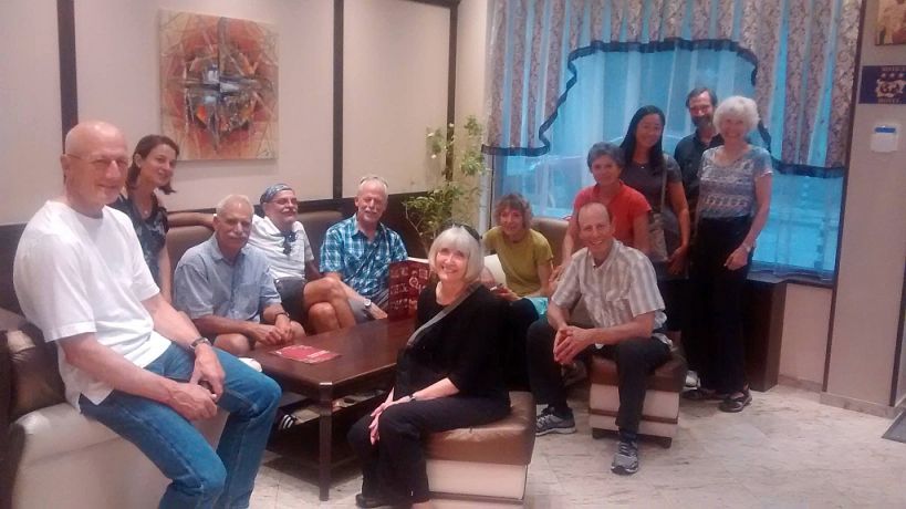
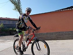
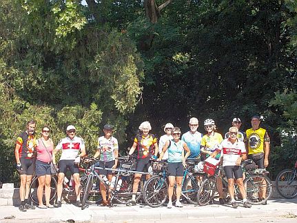
October 2014 I and Ken have began to speak about 3 week bicycle tour in Bulgaria, and the moment for it comes. So, I and Maya will be glad to guide this big group in Rodopi Mountains. WELLCOME Ken&Mimi, Eric&Devon, Bob&Donna, Rick&Theresa, Terry&Anne !!! So far we did not guide so big group. I will bicycle with them, Maya will support us by a car. |
|
|
|
Unfortunately I have no more space to upload more photos of this amassing tour ... |
 |
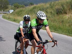
Ken & Mimi |
 |
 |
Bob & Donna |
 |
 |
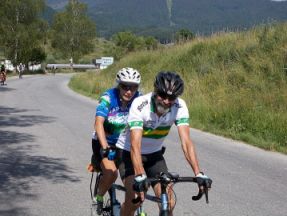
Rick & Theresa | |
 |
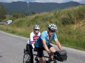
Terry & Anne | |
 |
Eric & Devon Here is the link to Eric's blog for the tour we did 19th June - 2nd July 2016: http://northwestbybike.blogspot.bg/
|
|
 |
||
|
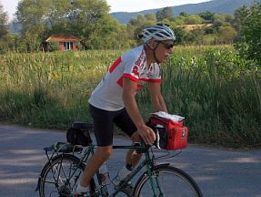
Well, I can say that so far I have never bicycled with so fast bicyclists. In fact bikers among the group were racers, not touring bicyclists like me. Luckily Maya were able to follow them by the car (I arrived 1-2 hours later). Never mind, I think in the end it was a really exciting tour - we explored Rodopi Mountains.
In the end I would like to mention, an exciting 380 page novel can be written about this trip, unfortunately my abilities are in other field, so I leave it to Ken's summary and Eric's blog (http://northwestbybike.blogspot.bg/ ). Ken's Summary:
19. 06. 2016
First of all,
indulge spelling and grammar errors. Due to recent eye surgery my
ability to read is temporarily compromised. Auto spell still works it's
mischief but I often cannot see what I typed. Photo captions are
affected by the, too. Photos of the hike and today's ride are at: https://picasaweb.google.com/mfield8888/6297927338463123553?authkey=Gv1sRgCJW73tT36c_z9AE#
We started to ride out of Sofia at 7 a.m. in minimal Sunday morning traffic for the first 10 miles after which traffic was generally light to non existent. It was already over 70 degrees when we started. We had a great stop for crepes after about 29 miles. 2.5 lev ($1.40) for a huge crepes big enough for 2 people. A big well made coffee was 1 lev----30 cents! We arrived at a pleasant hotel where a half liter of very good draft beer is 2.4 lev---$1.42. Dolna Banya means Lower Bath. The area has hit springs, so of course hotel had a pool and tub. The route is in the link at the bottom of this email. You should get an option to open the link in Google Earth If you right click n it, or press and hold on an iPad. Just tapping the link will give you an exciting list of numbers.
22. 06. 2016
We have finished our third day of riding. Each day has ended in different geography. Dolna Banya (end of the first day) was at about 1900 feet in the beginning of foothills to higher mountains, with a major ski area some distance away with high speed lifts (Borovets). The next day's ride was a long gradual descent ending in the flat plain around Varvara, at about 900 feet. Today we had a short 20 mile ride, but the last 11 miles was a major climb to St Konstantin. St. K. is a small village of mostly newer vacation homes at 4355 feet. There are indications that there is a small poma lift here in the winter, not much more than a small beginner's hill. See photos.
Weather so far has been very good, although a little on the warm side. It is much more comfortable up here.
Prices are often surprisingly low. See the photos for prices of Johnny Walker and Jack Daniels. Lunch for two with two beers runs about $8. And from the standpoint of square footage, space, and quality of the room, the hotel at St. K. provides about the best bang for the buck anywhere we've been. 50 lev, or $30, for a large apartment in a new facility. German quality at way below Mexican prices.
A picture of the map of th ride, and kml and gpx files, are provided below courtesy of my Bad Elf.
Photos of Dolna Banya to Varvara are at:
Varvara to St. Konstantin are at: https://picasaweb.google.com/mfield8888/6298732049912129425
Varvara to St. Konstantin 2016-06-21 Details:
A few comments about cycling in Bulgaria. Thanks to Boris's local knowledge all of the riding has been on very quiet roads, with an occasional short section of modest traffic. Road quality is generally good, occasionally very good, and thanks to Boris, rarely very bad. We have only had one section of about 4 km where the surface was more pothole than pavement. Autos and trucks are patient and pass safely.
I knew before I decided to come here that although Bulgaria has a history, it is markedly less visible. Very few towns have old buildings, as in 15-19 century. I guess things kept getting destroyed here. You don't have the feeling that you get cycling through the much of the rest of Europe (and especially Czech Republic, Slovakia, Spain and Italy) that you are cycling through history. Since I knew that, why did I come? Because after reading Boris's web site I thought it would be fun to cycle Bulgaria with Boris and his daughter. I have not been disappointed.
The ride today was only 35 miles to a small town, Yundola. The last ten miles we up hill, but not as steep as yesterday. Some of us had contemplated riding an extra 20-25 miles and 2300 feet up to a reservoir, but when we got to Yundola we took a short stop. After a beer or two, bread, cheese, chicken soup, and chicken kabobs we skipped the reservoir. Good thing. We hired an extra car (in addition to our Ford Focus sag) and drove up. It would have been a grueling end to an otherwise pleasant ride.
Below are Bad Elf tracks of the ride in a photo, kml and gpx file. Photos of the ride today are at: https://picasaweb.google.com/mfield8888/6299017999636297121#
https://picasaweb.google.com/mfield8888/6299017999636297121?authkey=Gv1sRgCITUm7v3tN7F7AE
Yundola to Dobrinishte. 2016-06-23 Details
25. 06. 2016 Per the prior email we arrived in Dobrinishte on Thursday. We spent all day Friday in and around Dobrinishte, Bansko, and the mountains. More chairlifts up to 7300 feet, narrow gauge train ride to Bansko, a thunder storm Friday afternoon after we were ell situated in our pension drinking our hosts excellent home made wine. Saturday we had another 20 mile downhill to Ognyanovo. After a short stop at the rooms Boris arranged, most of us elected to ride another 11 miles and 2400 feet up to a village above a gorge, Kovachevitsa. Houses there are all stone with slate roofs. Then we had a long descent back to the rooms. Then beer, a swim in a small pool, dinner (choice of lamb, spaghetti, chicken kebabs) wine, Johnny Walker and Bulgarian brandy. Weather remains perfect. Some tandems said "best ride ever." Boris and Maya say each day will be better than the last. After a full week with them, I have complete confidence in them.
Pictures are at: https://picasaweb.google.com/mfield8888/6299773264883188769?authkey=Gv1sRgCIiXvsPd4--cZw and https://picasaweb.google.com/mfield8888/6300147486731775009?authkey=Gv1sRgCJ7_2IDt04iI7AE
Bad Elf map of today's ride, followed by links to GPS and kml, follow. The kml will open in Google Earth.
Dobrinishte to Ognyanovo and Kovachevitsa Details
27. 06. 2016
Each day just gets better and better. Today (Monday) we had a beautiful but short ride in the sunshine through a narrow gorge. Arrived at the Hotel Yagodina to sounds of "welcome to the Hotel California." We had enough time to order beer but not drink it before the thunderstorm struck. Here are links to photos of Sunday and Monday, followed by Bad Elf maps and files of Both rides. The kml file at the bottom opens in Google Earth.
Ognyanovo to Dospat: https://picasaweb.google.com/mfield8888/6300511626934689841?authkey=Gv1sRgCNDgg9ifrpXy5gE
Dospat to Yagodina: https://picasaweb.google.com/mfield8888/6300842715475227729?authkey=Gv1sRgCKGo2uXLvcivAQ
Dospat to Yagodina 2016-06027 Detail
Ognyanovo to Dospat June 26,2016 Details
01. 06. 2016 We are almost done with our trip. Overall the experience has exceeded expectations. Cycle routes are quiet, scenic, decently paved, and sufficiently challenging. A few days the mileage was on the short side, finishing by noon, but on those two days the thunderstorms started at 12:15. Timing was good, and we have not had any rain while riding. We cycled out of the mountains today (Friday July 1) and onto the plains east of Sofia. We are in a fairly large city, Pazardzhik (pop. About 70,000). It is hot and sunny down here. The map and track at the end of this email are from a few days ago, leaving Yagodina. In Yagodina, we were treated to a group of 4 local ladies doing traditional Bulgarian folk song and dances. These ladies then encouraged several members of our group to don Bulgarian folk garb and participate. The map and track at the end of this email are from a few days ago, leaving Yagodina. In Yagodina, we were treated to a group of 4 local ladies doing traditional Bulgarian folk song and dances. These ladies then encouraged several members of our group to don Bulgarian folk garb and participate. After the old night of dancing we rode partway back down the gorge shown in my earlier email. We the made a hard right turn up another gorge to "The Devil's Throat." This large underground cave is the entrance to Hades, and is the location where Otpheus entered the underworld to bring Eurydice back. He made it out, she did not. We did not see her.
Photos are included at: https://picasaweb.google.com/mfield8888/6301664165325418145?authkey=Gv1sRgCJ-v66nSvfna1wE
From Devin we have had good riding down to Pazardzhik. Photos are at: https://picasaweb.google.com/mfield8888/6302335083092983569?authkey=Gv1sRgCImenOKpyvfXmAE#
We get back to Sofia Saturday, and fly home Tuesday, 7/5.
The big almost flat spot in the altitude graph below is the time in Devil's Throat. Despite the long way down, we ended up higher than when we entered the cave. We were all surprised to walk back down.
Jagodina to Devil's Throat and Devin June 28, 2016 Details
|
||||||||||||||||||||||||||||||||||||||||||||||||||||||||||||||||||||||||||||||||||||||||||||||||||||||||||||||||||||||||||||||||||||||||||||||||||||||||||||||||||||||||||||||||||||||||||||||||||||||||||||||||||||||||||||||||
![]()
![]()
![]()
![]()
![]()
![]()
![]()
![]()
![]()
![]()
![]()
![]()
![]()